

Strathclyde Geoconservation and East Dunbartonshire Council have worked together over many years to achieve an audit of the stunning geodiversity of the area. (Click here to access the audit.) 34 sites have been designated in the Local Plan as Local Geodiversity Sites. Crow Road and Twechar are the first sites to be explained on beautifully illustrated panels:
To view the panels in more detail, and download the pictures if required, click here.
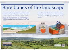
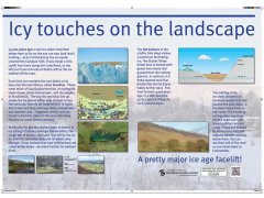
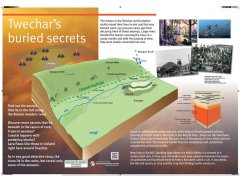
A group of four from SGG devised the site interpretation with EDC providing the graphic design and funding via the Civic Pride Fund. The panels explain the geology and landscape evolution of the Campsie Fells – Kelvin valley area, between Lennoxtown and Barhill. The panels in the car park on the Crow Road, the B822 between Lennoxtown and Fintry, explain the landscape seen from this popular viewpoint in terms of the rocks beneath and the effects of the ice age. A third board is beside the Healthy Living & Enterprise Centre in Twechar, off the Main Street. This panel relates the underlying geology to the area’s mining history and the landscape, with igneous rocks forming the higher ground and sandstones and shales under the River Kelvin floodplain.