

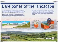
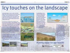
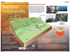
A group of four from Strathclyde Geoconservation Group devised three interpretation boards explaining the geology and landscape evolution of the Campsie Fells – Kelvin valley area, between Lennoxtown and Barhill. With East Dunbartonshire Council providing graphic design and funding, two panels have been erected in the car park on the Crow Road, the B822 between Lennoxtown and Fintry. These explain the landscape seen from this popular viewpoint in terms of the rocks beneath and the effects of the ice age. A third board is beside the Healthy Living & Enterprise Centre in Twechar, off the Main Street. This panel relates the underlying geology to the area’s mining history and the landscape, with igneous rocks forming the higher ground and sandstones and shales under the River Kelvin floodplain.
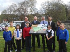
At the official press launch at Twechar on Thursday 24 April, Councillor Ashay Ghai, depute leader of East Dunbartonshire Council said he was pleased that the area’s geological significance was being promoted by the Council and Strathclyde Geoconservation Group working together. Local school children enjoyed learning about some of the geological secrets beneath their feet!
Iain Stewart has said “For me, as a West of Scotland lad, my personal favourite home-grown volcanic landscape is the Campsie Fells”.
The panels are shown below. To view them in more detail, and download the pictures if required, click here.
How to find the panels
Crow Road panels (grid ref. NS 613801). From the south, follow the A891 to Lennoxtown then head north and uphill on the B822 for about 1.8 miles to the car park on the left on a tight bend. From the north, take the B818 or B822 to Fintry. Follow the B822 south through the Campsie Fells and over its crest. The car park is on the right just before the sharp left-hand bend, which is 5.2 miles from the B818/B822 junction to the east of Fintry.
Twechar panel (postcode G65 9TA ; grid ref. NS 700753). From the west, take the A803 through Kirkintilloch to the junction, on the right, with the B8023. Follow this road for 2.1 miles then turn right over a bridge across the Forth and Clyde Canal into Main Street. Drive south for 0.4 miles then turn right into St Johns Way towards the Healthy Living & Enterprise Centre. The panel is at the edge of the grass area opposite the entrance. From the east, take the B802 south from Kilsyth to the junction with the B8023 at Auchinstarry. Follow the B8023 for 1.6 miles and turn left into Main Street, then as above. From the south follow the B8048 from Cumbernauld until the road crossed a railway bridge and turn sharp right into Main Street. After 1 mile turn left into St Johns Waytowards the Healthy Living & Enterprise Centre.